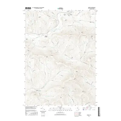
2016 Map of Hobart
USGS Topo · Published 2016About this map
The West Branch Delaware River carves a central path through this Delaware County landscape, anchoring the settlements of Hobart and South Kortright. To the south, the terrain becomes increasingly complex as the headwaters of the Little Delaware River and Platte Kill drain numerous valleys, including Meeker Hollow and Thompson Hollow. This area is characterized by high peaks such as Plattekill Mtn and Lyon Mtn, where gaps like Carmans Notch provided essential passage through the Catskill foothills. Local history is well-preserved through several established burial grounds, including Locust Hill Cem and Valley View Cem. The network of backroads, such as Roses Brook Rd and McMurdy Hill Rd, illustrates how the community adapted to the steep slopes and narrow valleys of the western Catskills.
Find a feature on this map
92 named features on this map. Tap any name to fly to it.
Don’t see what you’re looking for? This feature index may not catch every label — zoom into the map to look around manually.
Map Details
Editions of this 2016 Hobart Map
This is the sole edition of this map. No revisions or reprints were ever made.
Other maps of this area

1901 · Margaretville
USGS Topo · 1:62,500

1904 · Hobart
USGS Topo · 1:62,500

1904 · Margaretville
USGS Topo · 1:62,500

1909 · Delhi
USGS Topo · 1:62,500

1911 · Delhi
USGS Topo · 1:62,500

1922 · Andes
USGS Topo · 1:62,500

1924 · Andes
USGS Topo · 1:62,500

1943 · Bloomville
USGS Topo · 1:24,000
1943 · Davenport
USGS Topo · 1:24,000
1945 · Davenport
USGS Topo · 1:31,680