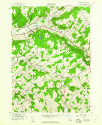
1943 Map of Davenport
USGS Topo · Published 1960About this map
The Charlotte Valley defines the northern reaches of this map, where the Middle Brook joins Charlotte Creek near the settlement of Davenport. This wartime survey captures a landscape of rural hamlets and small-scale agriculture connected by the New York Central railroad, which threads through the southern half of the quadrangle. The rail line served key points like Kortright Station and Doonan Corners, facilitating the movement of goods in an era when small dairy farms and creamery ponds were central to the local economy.
Find a feature on this map
38 named features on this map. Tap any name to fly to it.
Don’t see what you’re looking for? This feature index may not catch every label — zoom into the map to look around manually.
Map Details
Editions of this 1943 Davenport Map
3 editions found
Other maps of this area

1904 · Richmondville
USGS Topo · 1:62,500

1904 · Hobart
USGS Topo · 1:62,500

1907 · Cooperstown
USGS Topo · 1:62,500

1909 · Cooperstown
USGS Topo · 1:62,500

1909 · Delhi
USGS Topo · 1:62,500

1911 · Delhi
USGS Topo · 1:62,500

1943 · Delhi
USGS Topo · 1:24,000

1943 · Milford
USGS Topo · 1:24,000

1943 · Bloomville
USGS Topo · 1:24,000

1943 · Charlotteville
USGS Topo · 1:24,000