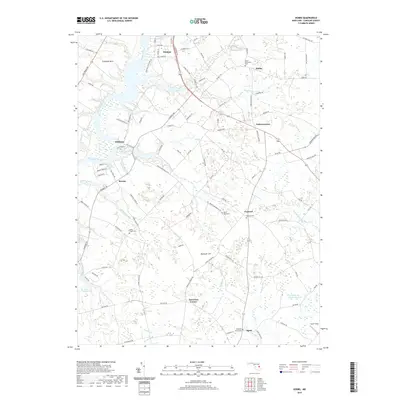
2019 Map of Hobbs
USGS Topo · Published 2019About this map
The Choptank River forms the western boundary of this landscape, carving through the Maryland Eastern Shore where the water-based trade routes of previous centuries meet modern agricultural life. Scattered across the Caroline County interior are small, historic settlements such as American Corner, Andersontown, and Concord, each serving as a crossroads for the surrounding farms. The local genealogy is well-documented through numerous burial grounds, including the Ames Methodist Cem, Todds Chapel Cem, and Saint Paul Cem, which anchor the small communities and provide a sense of long-standing family lineage in the region. The map highlights a network of drainage branches and creeks like Watts Creek and Fowling Cr that feed into the Choptank, defining the low-lying terrain. Towards the south, Smithville Community Lake and Lake Pinehurst offer distinct water features within an otherwise creek-dominated hydrology.
Find a feature on this map
107 named features on this map. Tap any name to fly to it.
Don’t see what you’re looking for? This feature index may not catch every label — zoom into the map to look around manually.
Map Details
Editions of this 2019 Hobbs Map
This is the sole edition of this map. No revisions or reprints were ever made.
Other maps of this area

1905 · Denton
USGS Topo · 1:62,500

1905 · Hurlock
USGS Topo · 1:62,500

1915 · Seaford
USGS Topo · 1:62,500

1918 · Harrington
USGS Topo · 1:62,500

1944 · Denton
USGS Topo · 1:31,680
1944 · Preston
USGS Topo · 1:31,680

1944 · Federalsburg
USGS Topo · 1:31,680
1944 · Ridgely
USGS Topo · 1:31,680

1944 · Seaford
USGS Topo · 1:62,500

1944 · Hobbs
USGS Topo · 1:31,680