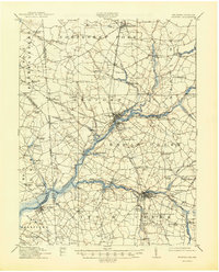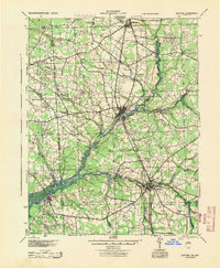
1944 Map of Seaford
USGS Topo · Published 1944About this map
The Nanticoke River defines the landscape of western Sussex County in this mid-1940s survey, serving as a primary artery for the Steamboat Route connecting inland ports. The river system supports a network of landings and crossings essential to the regional economy, including Cannons Ferry, Baileys Landing, and Ellis Wharf. Commercial activity is further evidenced by historic industrial sites such as Stephens Mill and the Old Furnace Mill, which hint at the area's transition from early iron production to milling.
Find a feature on this map
83 named features on this map. Tap any name to fly to it.
Don’t see what you’re looking for? This feature index may not catch every label — zoom into the map to look around manually.
Map Details
Editions of this 1944 Seaford Map
This is the sole edition of this map. No revisions or reprints were ever made.