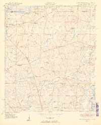
1950 Map of Hobbs Cross Roads
USGS Topo · Published 1950About this map
The Alabama-Florida state line divides this 1950 survey, where rural life in Holmes County is defined by the winding paths of the Pea River and the Choctawhatchee River. The landscape is a network of small agricultural settlements and family landmarks, centered on junctions like Hobbs Cross Roads and Sweet Gum Head. Transport and commerce at mid-century are anchored by points of river access and local gathering spots, including Stephens Ferry Bridge, Old Warehouse Landing, and the Barker Store.
Find a feature on this map
56 named features on this map. Tap any name to fly to it.
Don’t see what you’re looking for? This feature index may not catch every label — zoom into the map to look around manually.
Map Details
Editions of this 1950 Hobbs Cross Roads Map
2 editions found
Other maps of this area

1942 · Enterprise
USGS Topo · 1:125,000

1949 · Glendale
USGS Topo · 1:62,500

1949 · Hobbs Crossroads
USGS Topo · 1:24,000

1949 · Caryville
USGS Topo · 1:24,000

1950 · Hobbs Cross Roads
USGS Topo · 1:24,000

1950 · Prosperity
USGS Topo · 1:24,000

1950 · Caryville
USGS Topo · 1:24,000

1950 · Izagora
USGS Topo · 1:24,000

1951 · Glendale
USGS Topo · 1:62,500

1953 · Andalusia
USGS Topo · 1:250,000