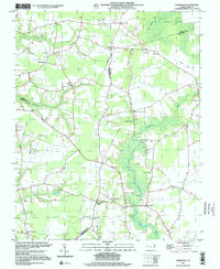
1997 Map of Hobbsville
USGS Topo · Published 2000About this map
The Great Dismal Swamp anchors the northeast corner of this landscape, where the flat coastal plains of the Inner Banks meet dense wetland reaches. The Perquimans River meanders south through the center of the sheet, its basin dotted with numerous community anchors like Winslow Grove Ch and Riddicks Grove Ch. Settlement patterns follow the higher ground between watercourses, with Hobbsville and Belvidere serving as local hubs. The presence of an Old Railroad Grade running through Sandy Cross and toward the swamp suggests the area's historical reliance on timber and rail transport. Dozens of small family and community cemeteries are scattered across the terrain, particularly around crossroads like Trotville and Byrum Crossroads, offering significant detail for those tracing local lineages in this quiet corner of Perquimans and Gates counties.
Find a feature on this map
32 named features on this map. Tap any name to fly to it.
Don’t see what you’re looking for? This feature index may not catch every label — zoom into the map to look around manually.
Map Details
Editions of this 1997 Hobbsville Map
This is the sole edition of this map. No revisions or reprints were ever made.
Other maps of this area

1904 · Edenton
USGS Topo · 1:62,500

1906 · Hertford
USGS Topo · 1:62,500

1906 · Beckford
USGS Topo · 1:48,000

1907 · Beckford
USGS Topo · 1:62,500

1940 · Hertford
USGS Topo · 1:62,500

1940 · Beckford
USGS Topo · 1:62,500

1940 · South Mills
USGS Topo · 1:62,500

1942 · Edenton
USGS Topo · 1:62,500

1943 · Edenton
USGS Topo · 1:62,500

1952 · South Mills
USGS Topo · 1:62,500