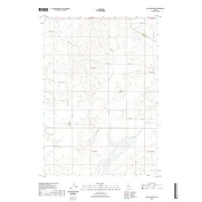
2020 Map of Hog Creek Butte
USGS Topo · Published 2020About this map
Hog Cr and its tributaries define the rolling drainage basins of Washington County, Idaho, where this 2020 map shows a landscape dominated by ranching infrastructure and remote access routes. The area is characterized by vast open spaces like Dutch Flat and the watershed of North Crane Creek, which flows into the Groner Reservoir in the southeastern quadrant. This modern survey illustrates how long-standing agricultural land use persists, with family-named routes such as Louie Faye Rd and Heinrich Rd providing the primary network through the foothills. A notable modern installation is the Coyote Ridge Airport, a small airstrip serving this isolated part of the state near the border with Adams County. The map provides a clear record of current property divisions and the intricate network of service roads, including Farm To Market Rd and Dixie Creek Rd, that connect the disparate creek valleys of Dixie Cr and Camp Cr.
Find a feature on this map
31 named features on this map. Tap any name to fly to it.
Don’t see what you’re looking for? This feature index may not catch every label — zoom into the map to look around manually.
Map Details
Editions of this 2020 Hog Creek Butte Map
This is the sole edition of this map. No revisions or reprints were ever made.
Other maps of this area

1894 · Squaw Creek
USGS Topo · 1:125,000

1897 · Weiser
USGS Topo · 1:125,000

1911 · Meadows
USGS Topo · 1:125,000

1954 · Council
USGS Topo · 1:62,500

1955 · Baker
USGS Topo · 1:250,000

1957 · Cambridge
USGS Topo · 1:62,500

1957 · Crane Creek Reservoir
USGS Topo · 1:62,500

1959 · Baker
USGS Topo · 1:250,000

1970 · Granger Butte
USGS Topo · 1:24,000
1970 · Riley Butte
USGS Topo · 1:24,000