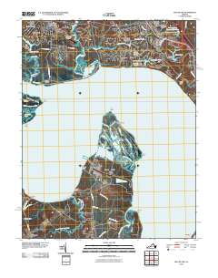
2010 Map of Hog Island
USGS Topo · Published 2010About this map
James River frontage and low-lying coastal peninsulas dominate this landscape south of Williamsburg in 2010. The map details the transition from the manicured developments of Kingsmill on the James and Kingspoint on the north bank to the expansive, marshy reaches of Hog Island and Gravel Neck to the south. Historically significant terrain is noted at Jamestown Island, where Travis Cemetery and a portion of the Colonial National Hist Park are preserved along the shoreline.
Find a feature on this map
73 named features on this map. Tap any name to fly to it.
Don’t see what you’re looking for? This feature index may not catch every label — zoom into the map to look around manually.
Map Details
Editions of this 2010 Hog Island Map
This is the sole edition of this map. No revisions or reprints were ever made.
Other maps of this area

1906 · Williamsburg
USGS Topo · 1:62,500

1907 · Yorktown
USGS Topo · 1:62,500

1917 · Toano
USGS Topo · 1:62,500

1918 · Toano
USGS Topo · 1:62,500

1919 · Surry
USGS Topo · 1:62,500

1943 · Yorktown
USGS Topo · 1:62,500

1943 · Richmond
USGS Topo · 1:250,000

1944 · Yorktown
USGS Topo · 1:24,000
1948 · Bacons Castle
USGS Topo · 1:24,000

1949 · Richmond
USGS Topo · 1:250,000