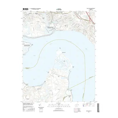
2016 Map of Hog Island
USGS Topo · Published 2016About this map
Hog Island dominates the center of this 2016 survey, sitting within the broad expanse of the James River. The landscape reveals a complex coastal environment where the Tribell Shoal Channel and Goose Hill Channel navigate the waters between James City Co and Surry Co. On the northern shore, residential developments such as Kingswood, Hollybrook, and Birchwood Park sit adjacent to the Williamsburg-Jamestown Airport and the expansive Colonial National Historical Park. South of the river, the terrain shifts to the rural character of Highgate and Chippokes, where College Run and Lower Chippokes Creek drain toward the Cobham Bay shoreline. This map illustrates the intersection of modern suburban growth near Williamsburg with the preserved marshlands and agricultural tracts of the lower James, including the notable peninsula of Gravel Neck.
Find a feature on this map
106 named features on this map. Tap any name to fly to it.
Don’t see what you’re looking for? This feature index may not catch every label — zoom into the map to look around manually.
Map Details
Editions of this 2016 Hog Island Map
This is the sole edition of this map. No revisions or reprints were ever made.
Other maps of this area

1906 · Williamsburg
USGS Topo · 1:62,500

1907 · Yorktown
USGS Topo · 1:62,500

1917 · Toano
USGS Topo · 1:62,500

1918 · Toano
USGS Topo · 1:62,500

1919 · Surry
USGS Topo · 1:62,500

1943 · Yorktown
USGS Topo · 1:62,500

1943 · Richmond
USGS Topo · 1:250,000

1944 · Yorktown
USGS Topo · 1:24,000
1948 · Bacons Castle
USGS Topo · 1:24,000

1949 · Richmond
USGS Topo · 1:250,000