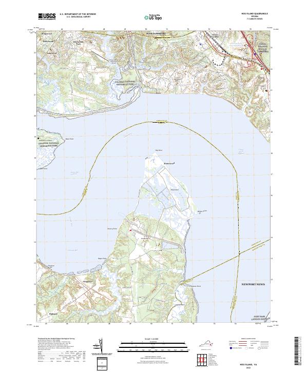
2022 Map of Hog Island
USGS Topo · Published 2022About this map
The James River serves as the central artery for this maritime landscape, dividing the peninsula of James City County from the northern reaches of Surry County. At the heart of the waterway sits Hog Island, a prominent landmass defined by its complex network of marshes and internal waters like Homewood Creek. This area illustrates the coexistence of federal land management and residential growth, with the Colonial National Historical Park and the Williamsburg-Jamestown Airport occupying significant portions of the northern shore. On the southern banks, the settlement of Chippokes and the high ground of Chestnut Bluffs overlook the Cobham Bay. The map also captures the strategic military footprint of the region, anchored by the Naval Weapons Station Yorktown and the northern edge of Joint Base Langley-Eustis, showing how modern defense and preservation efforts have shaped the contemporary layout of these ancient shores.
Find a feature on this map
54 named features on this map. Tap any name to fly to it.
Don’t see what you’re looking for? This feature index may not catch every label — zoom into the map to look around manually.
Map Details
Editions of this 2022 Hog Island Map
This is the sole edition of this map. No revisions or reprints were ever made.
Other maps of this area

1906 · Williamsburg
USGS Topo · 1:62,500

1907 · Yorktown
USGS Topo · 1:62,500

1917 · Toano
USGS Topo · 1:62,500

1918 · Toano
USGS Topo · 1:62,500

1919 · Surry
USGS Topo · 1:62,500

1943 · Yorktown
USGS Topo · 1:62,500

1943 · Richmond
USGS Topo · 1:250,000

1944 · Yorktown
USGS Topo · 1:24,000
1948 · Bacons Castle
USGS Topo · 1:24,000

1949 · Richmond
USGS Topo · 1:250,000