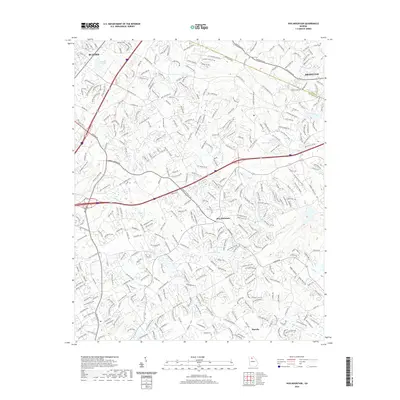
2020 Map of Hog Mountain
USGS Topo · Published 2020About this map
The ridge of Hog Mountain serves as a prominent geographic divide in this northern Georgia landscape, where the headwaters of several major river systems originate. The Apalachee River and Little Mulberry River flow toward the southeast, while the Yellow River and Alcovy River drain the southern reaches of the quadrangle. This 2020 survey reveals the modern suburban expansion surrounding the established hubs of Buford and Dacula, illustrating how residential road networks have integrated with older landmarks like Crowe Lake and Hogan Lake. For those tracing local heritage, several small burial grounds are documented, including Waters Cem near the northern border and McElroy Cem to the south. The transition from industrial corridors near Buford to the dense creek networks of Duncan Creek and Suwanee Cr provides a clear view of the area's contemporary development pattern.
Find a feature on this map
347 named features on this map. Tap any name to fly to it.
Don’t see what you’re looking for? This feature index may not catch every label — zoom into the map to look around manually.
Map Details
Editions of this 2020 Hog Mountain Map
This is the sole edition of this map. No revisions or reprints were ever made.
Other maps of this area

1888 · Atlanta
USGS Topo · 1:125,000

1890 · Suwanee
USGS Topo · 1:125,000

1890 · Atlanta
USGS Topo · 1:125,000

1891 · Gainesville
USGS Topo · 1:125,000

1892 · Atlanta
USGS Topo · 1:125,000

1894 · Suwanee
USGS Topo · 1:125,000

1895 · Atlanta
USGS Topo · 1:125,000

1896 · Monroe
USGS Topo · 1:125,000

1953 · Atlanta
USGS Topo · 1:250,000

1953 · Athens
USGS Topo · 1:250,000