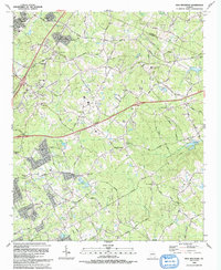
1992 Map of Hog Mountain
USGS Topo · Published 1993About this map
Hog Mountain serves as a prominent landmark in this Gwinnett County landscape, positioned between the upper reaches of the Alcovy River and the Little Mulberry River. The 1992 survey documents a region undergoing suburban transition, where historical rural identifiers like Harmony Sch and the Gravel Springs Ch Cem meet modern developments including the Phillips Correction Facility and several new subdivisions. A high density of churches and family cemeteries, such as Waters Cem and McElroy Cem, underscores the area's deep-rooted community history.
Find a feature on this map
91 named features on this map. Tap any name to fly to it.
Don’t see what you’re looking for? This feature index may not catch every label — zoom into the map to look around manually.
Map Details
Editions of this 1992 Hog Mountain Map
This is the sole edition of this map. No revisions or reprints were ever made.
Other maps of this area

1888 · Atlanta
USGS Topo · 1:125,000

1890 · Suwanee
USGS Topo · 1:125,000

1890 · Atlanta
USGS Topo · 1:125,000

1891 · Gainesville
USGS Topo · 1:125,000

1892 · Atlanta
USGS Topo · 1:125,000

1894 · Suwanee
USGS Topo · 1:125,000

1895 · Atlanta
USGS Topo · 1:125,000

1896 · Monroe
USGS Topo · 1:125,000

1953 · Atlanta
USGS Topo · 1:250,000

1953 · Athens
USGS Topo · 1:250,000