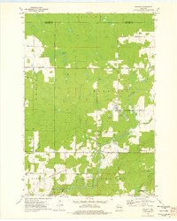
1973 Map of Hogarty
USGS Topo · Published 1976About this map
The Eau Claire River cuts through the townships of Harrison, Easton, and Plover in this early 1970s survey of north-central Wisconsin. The landscape is defined by its active resource extraction and conservation, featuring numerous quarries and a gravel pit alongside the protected Dells of the Eau Claire Park and Plover River State Fishery Area. Small rural communities like Hogarty and Snell serve as local hubs, while an Old RR Grade hints at earlier timber or freight corridors that once traversed the region.
Find a feature on this map
33 named features on this map. Tap any name to fly to it.
Don’t see what you’re looking for? This feature index may not catch every label — zoom into the map to look around manually.
Map Details
Editions of this 1973 Hogarty Map
This is the sole edition of this map. No revisions or reprints were ever made.
Other maps of this area

1899 · Wausau
USGS Topo · 1:125,000

1902 · Wausau
USGS Topo · 1:125,000

1951 · Doering
USGS Topo · 1:48,000

1952 · Antigo
USGS Topo · 1:48,000

1953 · Hatley
USGS Topo · 1:48,000

1954 · Wittenberg
USGS Topo · 1:48,000

1954 · Iron Mountain
USGS Topo · 1:250,000

1955 · Green Bay
USGS Topo · 1:250,000

1959 · Iron Mountain
USGS Topo · 1:250,000

1964 · Wittenberg
USGS Topo · 1:62,500