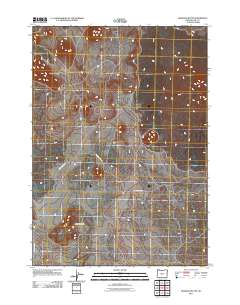
2011 Map of Hogback Butte
USGS Topo · Published 2011About this map
Hogback Butte rises as a prominent landmark in this high-desert portion of Lake County during the early 21st century. The landscape is primarily defined by significant geological formations, including the broad plateau of Table Mountain situated to the south. This region of Oregon is characterized by its sparse infrastructure, where the primary movement through the terrain is facilitated by a network of rural routes such as County Hwy-5-12 and its branches, County Hwy-5-12b and County Hwy-5-12c. The map illustrates a high-plateau environment where natural topography dictates the path of local roads, reflecting the isolation and rugged nature of the Oregon outback. The drainage patterns visible on the sheet suggest a seasonal water system typical of this arid climate, where elevation changes between the buttes and the surrounding basin are the primary geographic features.
Find a feature on this map
5 named features on this map. Tap any name to fly to it.
Don’t see what you’re looking for? This feature index may not catch every label — zoom into the map to look around manually.
Map Details
Editions of this 2011 Hogback Butte Map
This is the sole edition of this map. No revisions or reprints were ever made.
Other maps of this area

1955 · Crescent
USGS Topo · 1:250,000

1957 · Crescent
USGS Topo · 1:250,000

1958 · Crescent
USGS Topo · 1:250,000

1970 · Crescent
USGS Topo · 1:250,000

1981 · Fox Butte
USGS Topo · 1:24,000

1981 · Hogback Butte
USGS Topo · 1:24,000

1981 · Cougar Mtn
USGS Topo · 1:24,000

1981 · Lane Lake
USGS Topo · 1:24,000
1982 · Schaub Lake
USGS Topo · 1:24,000
1982 · Sixteen Butte
USGS Topo · 1:24,000