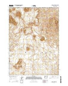
2014 Map of Hogback Butte
USGS Topo · Published 2014About this map
Hogback Butte and Table Mtn anchor this high-elevation landscape in Lake County, Oregon, where the terrain is marked by distinct volcanic features and isolated watering holes. The area is defined by a remote network of tracks and access points, including Derricks Cave Rd and Kittredge Ln, which navigate the rises and flats of the High Desert. This 2014 survey records the essential water infrastructure of the region, specifically Ward Wls and Jaynes Wls, which remain critical landmarks in a region dominated by sagebrush and seasonal drainage. These named wells and the intersection of Sink Ln illustrate the ongoing reliance on established ranching and grazing access routes that have served this portion of the Oregon outback for generations.
Find a feature on this map
12 named features on this map. Tap any name to fly to it.
Don’t see what you’re looking for? This feature index may not catch every label — zoom into the map to look around manually.
Map Details
Editions of this 2014 Hogback Butte Map
This is the sole edition of this map. No revisions or reprints were ever made.
Other maps of this area

1955 · Crescent
USGS Topo · 1:250,000

1957 · Crescent
USGS Topo · 1:250,000

1958 · Crescent
USGS Topo · 1:250,000

1970 · Crescent
USGS Topo · 1:250,000

1981 · Fox Butte
USGS Topo · 1:24,000

1981 · Hogback Butte
USGS Topo · 1:24,000

1981 · Cougar Mtn
USGS Topo · 1:24,000

1981 · Lane Lake
USGS Topo · 1:24,000
1982 · Schaub Lake
USGS Topo · 1:24,000
1982 · Sixteen Butte
USGS Topo · 1:24,000