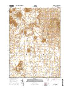
2017 Map of Hogback Butte
USGS Topo · Published 2017About this map
Hogback Butte and Table Mtn dominate the volcanic landscape of this Lake County terrain, where high-desert plateaus are defined by dramatic contour changes and an sparse network of rural roads. The area is marked by a unique system of volcanic features and land management lines, including the transition between t24s r16e, t25s r15e, and t25s r16e. Access through this open country is provided by several distinct routes such as Derrick Cave Rd and Sink Rd. The map illustrates the characteristic isolation of the Oregon outback, where local names like Sink Ln and Morrison Ln indicate the few established paths through the high-elevation flats. This survey provides an essential look at the physical geography of the region as it existed in 2017.
Find a feature on this map
11 named features on this map. Tap any name to fly to it.
Don’t see what you’re looking for? This feature index may not catch every label — zoom into the map to look around manually.
Map Details
Editions of this 2017 Hogback Butte Map
This is the sole edition of this map. No revisions or reprints were ever made.
Other maps of this area

1955 · Crescent
USGS Topo · 1:250,000

1957 · Crescent
USGS Topo · 1:250,000

1958 · Crescent
USGS Topo · 1:250,000

1970 · Crescent
USGS Topo · 1:250,000

1981 · Fox Butte
USGS Topo · 1:24,000

1981 · Hogback Butte
USGS Topo · 1:24,000

1981 · Cougar Mtn
USGS Topo · 1:24,000

1981 · Lane Lake
USGS Topo · 1:24,000
1982 · Schaub Lake
USGS Topo · 1:24,000
1982 · Sixteen Butte
USGS Topo · 1:24,000