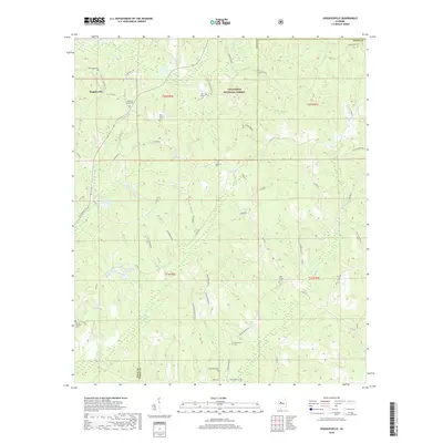
2018 Map of Hogglesville
USGS Topo · Published 2018About this map
Hogglesville and the surrounding woods of Talladega National Forest define this landscape along the border of Hale and Perry counties. The area is heavily marked by its rural heritage, with a dense network of country roads like Starling Rd and Bluff Springs Rd connecting numerous community burial grounds. These sites, including New Hope Cem, Old Shiloh Cem, and Faith Chapel Cem, suggest a history of long-standing family settlements and local congregations scattered throughout the timberlands.
Find a feature on this map
59 named features on this map. Tap any name to fly to it.
Don’t see what you’re looking for? This feature index may not catch every label — zoom into the map to look around manually.
Map Details
Editions of this 2018 Hogglesville Map
This is the sole edition of this map. No revisions or reprints were ever made.
Other maps of this area

1953 · Montgomery
USGS Topo · 1:250,000

1956 · Montgomery
USGS Topo · 1:250,000

1957 · Montgomery
USGS Topo · 1:250,000

1979 · Marion North
USGS Topo · 1:24,000

1979 · Morgan Springs
USGS Topo · 1:24,000

1979 · Greensboro
USGS Topo · 1:24,000

1979 · Pondville
USGS Topo · 1:24,000

1980 · Payne Lake
USGS Topo · 1:24,000

1980 · Ingram
USGS Topo · 1:24,000
1980 · Hogglesville
USGS Topo · 1:24,000