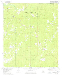
1980 Map of Hogglesville
USGS Topo · Published 1980About this map
The Talladega National Forest dominates this west-central Alabama landscape, where the Perry, Hale, and Bibb county lines converge. The settlement of Hogglesville and nearby Wateroak are centers of community life defined by a dense network of country churches and family burial grounds. Waterways like Fivemile Creek and Sparks Creek carve through the wooded terrain, providing natural boundaries for timber and agricultural tracts. A notable concentration of spiritual landmarks, including Morgan Tabernacle, Faith Chapel, and Bethany Ch, highlights the cultural significance of these small crossroads communities. This 1980 update to the mid-century topographic data records the enduring rural character of the region, specifically noting scattered industrial features like a Gravel Pit and the small hamlet of North Perry.
Find a feature on this map
29 named features on this map. Tap any name to fly to it.
Don’t see what you’re looking for? This feature index may not catch every label — zoom into the map to look around manually.
Map Details
Editions of this 1980 Hogglesville Map
2 editions found
Other maps of this area

1953 · Montgomery
USGS Topo · 1:250,000

1956 · Montgomery
USGS Topo · 1:250,000

1957 · Montgomery
USGS Topo · 1:250,000

1979 · Marion North
USGS Topo · 1:24,000

1979 · Morgan Springs
USGS Topo · 1:24,000

1979 · Greensboro
USGS Topo · 1:24,000

1979 · Pondville
USGS Topo · 1:24,000

1980 · Payne Lake
USGS Topo · 1:24,000

1980 · Ingram
USGS Topo · 1:24,000
1980 · Moundville East
USGS Topo · 1:24,000