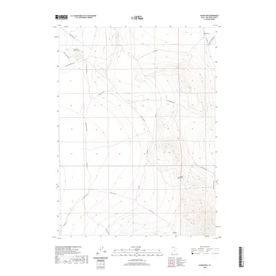
2020 Map of Hogup Bar
USGS Topo · Published 2020About this map
Hogup Bar and the adjacent Hogup Mountains define this high-desert region of Box Elder County. The landscape is marked by the distinct drainage patterns of Dove Cr, which flows into the Sinks of Dove Creek. Evidence of historical transportation infrastructure is visible in the corridor of the Old Railroad Grade Rd, reflecting the importance of rail transit in the development of Northern Utah. A network of rural tracks such as Board Ranch Rd and Government Well Rd indicates a history of ranching and water management in a region where such resources are scarce. The presence of Big Pass and various mountain roads like Hogup Cabin Rd suggests the primary routes used to navigate the local topography.
Find a feature on this map
19 named features on this map. Tap any name to fly to it.
Don’t see what you’re looking for? This feature index may not catch every label — zoom into the map to look around manually.
Map Details
Editions of this 2020 Hogup Bar Map
This is the sole edition of this map. No revisions or reprints were ever made.
Other maps of this area

1954 · Brigham City
USGS Topo · 1:250,000

1958 · Brigham City
USGS Topo · 1:250,000

1962 · Brigham City
USGS Topo · 1:250,000

1969 · Peplin Flats
USGS Topo · 1:24,000

1969 · Dolphin Island West
USGS Topo · 1:24,000

1969 · Crocodile Mtn NE
USGS Topo · 1:24,000

1969 · Hogup Bar
USGS Topo · 1:24,000
1969 · Crocodile Mtn SE
USGS Topo · 1:24,000

1971 · Matlin
USGS Topo · 1:24,000
1971 · Russian Knoll
USGS Topo · 1:24,000