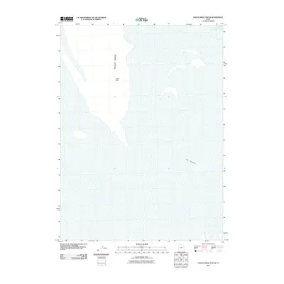
2011 Map of Hogup Ridge South
USGS Topo · Published 2011About this map
Hogup Ridge dominates the western portion of this Great Salt Lake desert landscape, terminating at the prominent Hogup Point. The eastern half of the map is defined by the expansive, salt-encrusted flats and shallow waters of the Fremont Strait, a remote stretch of the basin that highlights the stark, unpopulated character of Box Elder County during the early 21st century. Further south, the map identifies The Threshold, marking a transition in the basin's floor. This 2011 survey, produced by the U.S. Geological Survey, serves as a precise record of the shoreline and elevation contours in an area where the water levels of the Great Salt Lake fluctuate significantly, altering the relationship between the dry ridges and the surrounding alkaline flats.
Find a feature on this map
4 named features on this map. Tap any name to fly to it.
Don’t see what you’re looking for? This feature index may not catch every label — zoom into the map to look around manually.
Map Details
Editions of this 2011 Hogup Ridge South Map
This is the sole edition of this map. No revisions or reprints were ever made.
Other maps of this area

1954 · Brigham City
USGS Topo · 1:250,000

1958 · Brigham City
USGS Topo · 1:250,000

1962 · Brigham City
USGS Topo · 1:250,000

1969 · Gunnison Island SW
USGS Topo · 1:24,000

1969 · Hogup Ridge South
USGS Topo · 1:24,000

1969 · Strongs Knob
USGS Topo · 1:24,000

1969 · Hogup Ridge North
USGS Topo · 1:24,000

1983 · Round Mountain NW
USGS Topo · 1:24,000
1983 · Round Mountain SW
USGS Topo · 1:24,000
1983 · Round Mountain
USGS Topo · 1:24,000