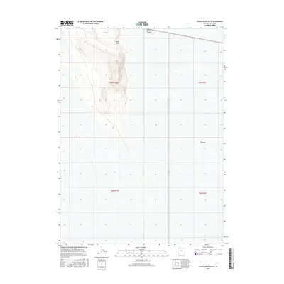
2017 Map of Hogup Ridge South
USGS Topo · Published 2017About this map
Hogup Ridge dominates this northern Utah landscape, rising above the vast salt flats of the Great Salt Lake desert. This survey highlights the topographic isolation of the ridge, culminating in Hogup Point, which provides a vantage over the surrounding dry basins. A critical piece of industrial infrastructure, the Southern Pacific Causeway, cuts across the northern edge of the sheet, illustrating how transportation corridors were engineered to bridge this challenging environment. To the east, a feature known as The Threshold marks the transition between the ridge's base and the open expanse of the salt desert, where township boundaries like t6n r11w and t6n r10w delineate the surveyed grid across an otherwise trackless terrain.
Find a feature on this map
8 named features on this map. Tap any name to fly to it.
Don’t see what you’re looking for? This feature index may not catch every label — zoom into the map to look around manually.
Map Details
Editions of this 2017 Hogup Ridge South Map
This is the sole edition of this map. No revisions or reprints were ever made.
Other maps of this area

1954 · Brigham City
USGS Topo · 1:250,000

1958 · Brigham City
USGS Topo · 1:250,000

1962 · Brigham City
USGS Topo · 1:250,000

1969 · Gunnison Island SW
USGS Topo · 1:24,000

1969 · Hogup Ridge South
USGS Topo · 1:24,000

1969 · Strongs Knob
USGS Topo · 1:24,000

1969 · Hogup Ridge North
USGS Topo · 1:24,000

1983 · Round Mountain NW
USGS Topo · 1:24,000
1983 · Round Mountain SW
USGS Topo · 1:24,000
1983 · Round Mountain
USGS Topo · 1:24,000