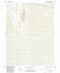
1991 Map of Hogup Ridge South
USGS Topo · Published 1991About this map
Lucin Cutoff traverses the northern edge of this desolate landscape, marking a vital engineering corridor through the Great Salt Lake desert. The terrain is dominated by the narrow spine of Hogup Ridge, terminating at Hogup Point, which rises above a vast expanse of Mud flats. This area represents a transition between the elevated ridge and the low-lying basins of the eastern Great Basin. Much of the southern portion of the quadrangle is occupied by the Utah Test and Training Range North, defined by the Military Reservation Boundary. The geographic feature known as The Threshold appears as a notable corridor between the mud flats, illustrating the unique topographical challenges faced by the railroad builders of the era. The mapping reflects a landscape of restricted access and significant geological scale.
Find a feature on this map
10 named features on this map. Tap any name to fly to it.
Don’t see what you’re looking for? This feature index may not catch every label — zoom into the map to look around manually.
Map Details
Editions of this 1991 Hogup Ridge South Map
This is the sole edition of this map. No revisions or reprints were ever made.
Other maps of this area

1954 · Brigham City
USGS Topo · 1:250,000

1958 · Brigham City
USGS Topo · 1:250,000

1962 · Brigham City
USGS Topo · 1:250,000

1969 · Gunnison Island SW
USGS Topo · 1:24,000

1969 · Hogup Ridge South
USGS Topo · 1:24,000

1969 · Strongs Knob
USGS Topo · 1:24,000

1969 · Hogup Ridge North
USGS Topo · 1:24,000

1983 · Round Mountain NW
USGS Topo · 1:24,000
1983 · Round Mountain SW
USGS Topo · 1:24,000
1983 · Round Mountain
USGS Topo · 1:24,000