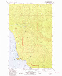
1982 Map of Hoh Head
USGS Topo · Published 1982About this map
The coastal wilderness of the Olympic Peninsula is preserved here in the early 1980s, where the Pacific Ocean meets a series of dramatic headlands and river mouths. Much of the coastline is protected under the Olympic National Park and specialized wildlife zones like the Quillayute Needles National Wildlife Refuge. A notable historical footprint is found at the Oil City (Site) near the Hoh River, a remnant of early 20th-century petroleum speculation further evidenced by the Jefferson Oil Seep. The landscape is defined by its drainage systems, including the complex forks of Goodman Creek and Mosquito Creek. Coastal features such as Hoh Head, Boulder Beach, and Caves near Jefferson Cove illustrate the maritime character of this shoreline, while scattered Gravel Pits indicate the practical resource extraction occurring just inland from the national park boundaries.
Find a feature on this map
28 named features on this map. Tap any name to fly to it.
Don’t see what you’re looking for? This feature index may not catch every label — zoom into the map to look around manually.
Map Details
Editions of this 1982 Hoh Head Map
2 editions found
Other maps of this area

1939 · Forks
USGS Topo · 1:62,500

1943 · Copalis Beach
USGS Topo · 1:250,000

1951 · Copalis Beach
USGS Topo · 1:250,000

1956 · Destruction Island
USGS Topo · 1:62,500

1956 · La Push
USGS Topo · 1:62,500

1957 · Forks
USGS Topo · 1:62,500

1957 · Copalis Beach
USGS Topo · 1:250,000

1963 · Copalis Beach
USGS Topo · 1:250,000
1981 · Forks
USGS Topo · 1:24,000
1981 · Reade Hill
USGS Topo · 1:24,000