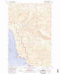
1982 Map of Hoh Head
USGS Topo · Published 1982About this map
Hoh Head and the adjacent Pacific Ocean coastline dominate this early 1980s topographical record of western Jefferson County. The map documents a rugged landscape where the Olympic National Park boundary meets the shoreline, preserved within the Pacific Ocean Wilderness. An interpretive highlight is the presence of the Oil City (Site) and a nearby Oil Seep, hinting at early industrial aspirations that gave way to conservation. The terrain is defined by a series of drainages, including Goodman Creek and Mosquito Creek, which flow toward a rocky coast featuring Boulder Beach, Diamond Rock, and numerous caves. This survey also delineates the northern edge of the Hoh Indian Reservation and the Washington Islands National Wildlife Refuge, capturing the intersection of indigenous land, federal preservation, and coastal geology.
Find a feature on this map
29 named features on this map. Tap any name to fly to it.
Don’t see what you’re looking for? This feature index may not catch every label — zoom into the map to look around manually.
Map Details
Editions of this 1982 Hoh Head Map
2 editions found
Other maps of this area

1939 · Forks
USGS Topo · 1:62,500

1943 · Copalis Beach
USGS Topo · 1:250,000

1951 · Copalis Beach
USGS Topo · 1:250,000

1956 · Destruction Island
USGS Topo · 1:62,500

1956 · La Push
USGS Topo · 1:62,500

1957 · Forks
USGS Topo · 1:62,500

1957 · Copalis Beach
USGS Topo · 1:250,000

1963 · Copalis Beach
USGS Topo · 1:250,000
1981 · Forks
USGS Topo · 1:24,000
1981 · Reade Hill
USGS Topo · 1:24,000