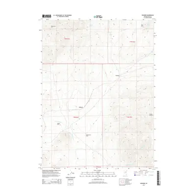
2014 Map of Holborn
USGS Topo · Published 2014About this map
Independence Valley serves as the central corridor of this Elko County landscape, flanked by the Windermere Hills to the northwest and the Pequop Mountains to the east. Small settlements and specialized locations such as Holborn, Fenelon, and the remote Holborn Field are tied together by the transport infrastructure crossing this high-desert basin. The presence of numerous water sources, including Wolfman Spring, Ralphs Spring, and Mud Spring, indicates the vital importance of reliable water in this arid region. Several drainages, most notably Independence Cr and Deadman Cr, cut through the terrain, illustrating the natural drainage patterns from the surrounding peaks into the valley floor. The map also delineates several township and range boundaries, such as t39n r64e and t38n r65e, reflecting the formal division of these public lands.
Find a feature on this map
20 named features on this map. Tap any name to fly to it.
Don’t see what you’re looking for? This feature index may not catch every label — zoom into the map to look around manually.
Map Details
Editions of this 2014 Holborn Map
This is the sole edition of this map. No revisions or reprints were ever made.
Other maps of this area

1955 · Wells
USGS Topo · 1:250,000

1958 · Wells
USGS Topo · 1:250,000

1961 · Wells
USGS Topo · 1:250,000

1968 · Moor Summit
USGS Topo · 1:24,000

1968 · Holborn
USGS Topo · 1:24,000

1968 · Melandco
USGS Topo · 1:24,000

1968 · Pequop
USGS Topo · 1:24,000
1968 · Pequop Summit SW
USGS Topo · 1:24,000

1968 · Wells Peak
USGS Topo · 1:24,000
1968 · Pequop Summit
USGS Topo · 1:24,000