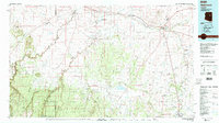
1980 Map of Holbrook
USGS Topo · Published 1996About this map
The Little Colorado River and Puerco River converge near Holbrook, a hub defined by the Atchison Topeka and Santa Fe railroad and the modern corridor of Interstate 40. This 1980 survey captures a landscape at the transition between the high desert plateaus and the heavily wooded canyons of the Coconino National Forest and Sitgreaves National Forest. To the south, Snowflake sits along Silver Creek, while the arid northern reaches are marked by wide drainages like Leroux Wash and Cottonwood Wash.
Find a feature on this map
32 named features on this map. Tap any name to fly to it.
Don’t see what you’re looking for? This feature index may not catch every label — zoom into the map to look around manually.
Map Details
Editions of this 1980 Holbrook Map
2 editions found
Other maps of this area

1883 · Tusayan
USGS Topo · 1:250,000

1886 · St Johns
USGS Topo · 1:250,000

1886 · Tusayan
USGS Topo · 1:250,000

1886 · Fort Defiance
USGS Topo · 1:250,000

1886 · San Francisco Mtns
USGS Topo · 1:250,000

1886 · Holbrook
USGS Topo · 1:250,000

1887 · Verde
USGS Topo · 1:250,000

1891 · San Francisco Mtns
USGS Topo · 1:250,000

1892 · Verde
USGS Topo · 1:250,000

1892 · Fort Defiance
USGS Topo · 1:250,000