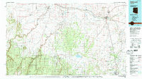
1980 Map of Holbrook
USGS Topo · Published 1996About this map
Holbrook serves as a critical junction in the high desert of northern Arizona, where the Atchison Topeka and Santa Fe RR and the Puerco River converge with the Little Colorado River. This 1980 survey captures a region defined by its reliance on water and rail, featuring established agricultural hubs like Joseph City and Snowflake alongside smaller trackside stops such as Penzance and Arntz. The map reveals a complex landscape of drainage systems, from the deep incisions of Chevelon Canyon and Black Canyon to the broad expanses of Tenmile Draw and Washboard Wash.
Find a feature on this map
80 named features on this map. Tap any name to fly to it.
Don’t see what you’re looking for? This feature index may not catch every label — zoom into the map to look around manually.
Map Details
Editions of this 1980 Holbrook Map
2 editions found
Other maps of this area

1883 · Tusayan
USGS Topo · 1:250,000

1886 · St Johns
USGS Topo · 1:250,000

1886 · Tusayan
USGS Topo · 1:250,000

1886 · Fort Defiance
USGS Topo · 1:250,000

1886 · San Francisco Mtns
USGS Topo · 1:250,000

1886 · Holbrook
USGS Topo · 1:250,000

1887 · Verde
USGS Topo · 1:250,000

1891 · San Francisco Mtns
USGS Topo · 1:250,000

1892 · Verde
USGS Topo · 1:250,000

1892 · Fort Defiance
USGS Topo · 1:250,000