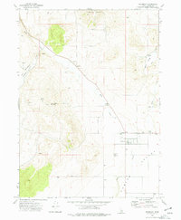
1973 Map of Holbrook
USGS Topo · Published 1977About this map
Holbrook serves as a remote hub in southern Idaho during the early 1970s, situated at the base of the Deep Creek Mountains within the sweeping expanse of the Curlew Valley. The settlement pattern is defined by agricultural infrastructure and water management, evidenced by numerous wells and isolated sites like the Rock House Ranch. Transportation in this arid landscape relies on a network of primitive routes, including a Jeep Trail and a Jeep Tr that provide access to higher elevations such as Lookout Mtn.
Find a feature on this map
21 named features on this map. Tap any name to fly to it.
Don’t see what you’re looking for? This feature index may not catch every label — zoom into the map to look around manually.
Map Details
Editions of this 1973 Holbrook Map
This is the sole edition of this map. No revisions or reprints were ever made.
Other maps of this area

1954 · Pocatello
USGS Topo · 1:250,000

1958 · Pocatello
USGS Topo · 1:250,000

1973 · The Cove
USGS Topo · 1:24,000
1973 · Roy
USGS Topo · 1:24,000
1973 · Stone
USGS Topo · 1:24,000
1973 · Badger Hole Spring
USGS Topo · 1:24,000
1973 · Sheep Creek Spring
USGS Topo · 1:24,000
1973 · Buist
USGS Topo · 1:24,000
1973 · Cedarhill
USGS Topo · 1:24,000
1973 · Co-op Spring
USGS Topo · 1:24,000