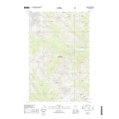
2020 Map of Holden
USGS Topo · Published 2020About this map
Wenatchee National Forest dominates this alpine landscape in the Entiat Mountains, where high-altitude geography is defined by prominent peaks and surviving glacial features. Massive summits including Bonanza Peak, Mt Fernow, and Mt Maude tower over the Entiat River headwaters, while the Isella Glacier and Mary Green Glacier persist in the upper reaches of the drainage. Historical land use is evidenced by labels such as Miner's Interp and Miner's Goat near Lower Railroad Creek, pointing to a legacy of prospecting and resource extraction in these remote drainages. Below the granite spires, the terrain transitions to lush openings like Spider Meadow and Entiat Meadows. Significant water features such as Hart Lake, Holden Lake, and the high-elevation Ice Lakes are connected by a network of seasonal streams, including Railroad Creek and Phelps Creek.
Find a feature on this map
62 named features on this map. Tap any name to fly to it.
Don’t see what you’re looking for? This feature index may not catch every label — zoom into the map to look around manually.
Map Details
Editions of this 2020 Holden Map
This is the sole edition of this map. No revisions or reprints were ever made.
Other maps of this area

1902 · Stehekin
USGS Topo · 1:125,000

1904 · Stehekin
USGS Topo · 1:125,000

1944 · Holden
USGS Topo · 1:62,500

1944 · Lucerne
USGS Topo · 1:62,500

1949 · Lucerne
USGS Topo · 1:62,500

1949 · Holden
USGS Topo · 1:62,500

1955 · Concrete
USGS Topo · 1:250,000

1958 · Concrete
USGS Topo · 1:250,000

1962 · Concrete
USGS Topo · 1:250,000
1963 · Agnes Mtn
USGS Topo · 1:24,000