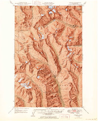
1949 Map of Holden
USGS Topo · Published 1949About this map
Holden Mine serves as the industrial anchor for this mountainous region, located at the terminus of a road following Railroad Creek. The mining settlement of Holden is mapped in detail, including a designated Recreational Area and various benchmarks. Further south, the settlement of Trinity sits near the confluence of Chiwawa River and Buck Creek, marking another hub of activity near the Red Mountain Mine. The map captures a high-altitude wilderness defined by the Entiat Mountains and the Chelan Range, where active ice fields like Lyman Glacier and Entiat Glacier feed the local watersheds.
Find a feature on this map
101 named features on this map. Tap any name to fly to it.
Don’t see what you’re looking for? This feature index may not catch every label — zoom into the map to look around manually.
Map Details
Editions of this 1949 Holden Map
3 editions found

Other maps of this area

1899 · Glacier Peak
USGS Topo · 1:125,000

1901 · Glacier Peak
USGS Topo · 1:125,000

1901 · Chiwaukum
USGS Topo · 1:125,000

1902 · Skykomish
USGS Topo · 1:125,000

1902 · Stehekin
USGS Topo · 1:125,000

1904 · Stehekin
USGS Topo · 1:125,000

1904 · Chiwaukum
USGS Topo · 1:125,000

1905 · Skykomish
USGS Topo · 1:125,000

1944 · Holden
USGS Topo · 1:62,500

1944 · Lucerne
USGS Topo · 1:62,500