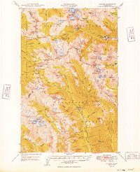
1949 Map of Holden
USGS Topo · Published 1949About this map
Holden serves as the industrial and social anchor of this high-elevation landscape, situated along Railroad Creek near the massive copper-mining operations of the Holden Mine. In the late 1940s, this region was a critical node of extraction and activity within the Chelan National Forest, where the presence of the Glacier Peak Mines and the Red Mountain Mine near Trinity reflect the era's reliance on mineral wealth. The map documents a rugged alpine environment defined by glaciers like the Luman Glacier and Entiat Glacier, alongside essential fire detection points such as the Carne Mtn Lookout. A network of footpaths, including the Phelps Ridge Trail and Little Giant Trail, provided the primary access through the surrounding Wenatchee National Forest, connecting remote outposts like Grou Camp to the industrial hubs.
Find a feature on this map
84 named features on this map. Tap any name to fly to it.
Don’t see what you’re looking for? This feature index may not catch every label — zoom into the map to look around manually.
Map Details
Editions of this 1949 Holden Map
3 editions found

Other maps of this area

1899 · Glacier Peak
USGS Topo · 1:125,000

1901 · Glacier Peak
USGS Topo · 1:125,000

1901 · Chiwaukum
USGS Topo · 1:125,000

1902 · Skykomish
USGS Topo · 1:125,000

1902 · Stehekin
USGS Topo · 1:125,000

1904 · Stehekin
USGS Topo · 1:125,000

1904 · Chiwaukum
USGS Topo · 1:125,000

1905 · Skykomish
USGS Topo · 1:125,000

1944 · Holden
USGS Topo · 1:62,500

1944 · Lucerne
USGS Topo · 1:62,500