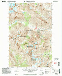
2004 Map of Holden
USGS Topo · Published 2008About this map
Holden sits as a significant human outpost in this high-altitude landscape, shaped largely by the industrial operations marked at the Mine and Mines along Railroad Creek. The presence of Tailings, Prospects, and Sewage Disp Ponds indicates the specialized infrastructure required for this remote mountain community. Surrounding the settlement, the terrain is dominated by massive peaks and glacial systems, including the Isella Glacier, Mary Green Glacier, and Company Glacier near Bonanza Peak. The boundaries of the Glacier Peak Wilderness and Wenatchee National Forest intersect here, preserving a landscape where the Entiat River originates from the Entiat Glacier and flows toward River Meadows. This map captures the intersection of heavy industrial extraction and protected wilderness at the start of the 21st century.
Find a feature on this map
57 named features on this map. Tap any name to fly to it.
Don’t see what you’re looking for? This feature index may not catch every label — zoom into the map to look around manually.
Map Details
Editions of this 2004 Holden Map
This is the sole edition of this map. No revisions or reprints were ever made.
Other maps of this area

1902 · Stehekin
USGS Topo · 1:125,000

1904 · Stehekin
USGS Topo · 1:125,000

1944 · Holden
USGS Topo · 1:62,500

1944 · Lucerne
USGS Topo · 1:62,500

1949 · Lucerne
USGS Topo · 1:62,500

1949 · Holden
USGS Topo · 1:62,500

1955 · Concrete
USGS Topo · 1:250,000

1958 · Concrete
USGS Topo · 1:250,000

1962 · Concrete
USGS Topo · 1:250,000
1963 · Agnes Mtn
USGS Topo · 1:24,000