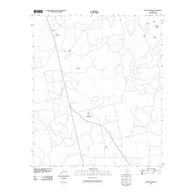
2010 Map of Holder Creek
USGS Topo · Published 2010About this map
The Divide forms the geographic backbone of this West Texas landscape, dictating the flow of ephemeral streams and the placement of cattle ranching operations during the early 21st century. High points such as Ninemile Hill and Wildcat Mountain overlook a network of draws and creeks, including Hoodoo Draw and the headwaters of Cottonwood Creek. The map reflects a rural economy centered on large landholdings like the Double Heart Ranch, connected by a web of county roads and farm-to-market routes. Local history is anchored at the Nolan Cemetery and water sources like Barrel Spring and Nolan Divide Lake, which serve as vital landmarks in this arid terrain. The presence of features like Little Blue Gainey Points and Merry Point suggests a landscape defined by its specific, often family-named, topographical elevations.
Find a feature on this map
30 named features on this map. Tap any name to fly to it.
Don’t see what you’re looking for? This feature index may not catch every label — zoom into the map to look around manually.
Map Details
Editions of this 2010 Holder Creek Map
This is the sole edition of this map. No revisions or reprints were ever made.
Other maps of this area

1893 · Sweetwater
USGS Topo · 1:125,000

1954 · Big Spring
USGS Topo · 1:250,000

1957 · Merkel
USGS Topo · 1:62,500

1958 · Big Spring
USGS Topo · 1:250,000

1967 · Hylton
USGS Topo · 1:24,000

1969 · Blackwell NE
USGS Topo · 1:24,000

1969 · Maryneal
USGS Topo · 1:24,000

1969 · Sweetwater
USGS Topo · 1:24,000

1969 · Holder Creek
USGS Topo · 1:24,000
1969 · Lake Sweetwater
USGS Topo · 1:24,000