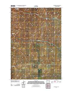
2011 Map of Holdman SE
USGS Topo · Published 2011About this map
North Fork Spring Canyon, Middle Fork Spring Canyon, and South Fork Spring Canyon cut through the high wheat-growing country of Umatilla County in this 2011 survey. The landscape is defined by a grid of agricultural section lines and rural roads that bear the names of local families and historic destinations. At the junction of Holdman Rd and Kings Corner Rd, the small settlement of Kings Corner serves as a central landmark for this farming plateau. The arterial Athena Holdman Hwy bisects the southern half of the map, providing a vital link between the upland fields and regional hubs. Other family-named thoroughfares such as Eggers Rd, Westerlund Rd, and Campbell Rd illustrate the long-standing land ownership patterns that have shaped this portion of the Inland Empire for generations.
Find a feature on this map
16 named features on this map. Tap any name to fly to it.
Don’t see what you’re looking for? This feature index may not catch every label — zoom into the map to look around manually.
Map Details
Editions of this 2011 Holdman SE Map
This is the sole edition of this map. No revisions or reprints were ever made.
Other maps of this area

1935 · Pendleton
USGS Topo · 1:125,000

1953 · Pendleton
USGS Topo · 1:250,000

1956 · Pendleton
USGS Topo · 1:250,000
1966 · Juniper Canyon
USGS Topo · 1:24,000

1966 · Holdman
USGS Topo · 1:24,000
1966 · Smeltz
USGS Topo · 1:24,000

1966 · Holdman SE
USGS Topo · 1:24,000

1966 · Pendleton
USGS Topo · 1:24,000

1966 · Mission
USGS Topo · 1:24,000
1966 · Ring
USGS Topo · 1:24,000