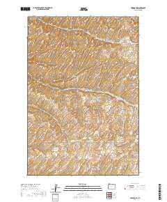
2020 Map of Holdman SE
USGS Topo · Published 2020About this map
North Fork Cold Springs Canyon and South Fork Cold Springs Canyon define the drainage patterns of this high plateau in Umatilla County. The landscape is marked by deeply incised gulches, including Missouri Gulch and Despain Gulch, which break the rolling agricultural surface. This 2020 survey reveals a sparse network of county roads and family-named lanes that trace the section lines and topography of the region. Notable transportation corridors such as Holdman Rd, S Cold Springs Rd, and Missouri Gulch Rd provide the primary access through these dry land farming tracts. The map also documents local landmarks like Kings Corner Rd and Eggers Rd, reflecting the long-standing rural property boundaries and ranching heritage of the area.
Find a feature on this map
26 named features on this map. Tap any name to fly to it.
Don’t see what you’re looking for? This feature index may not catch every label — zoom into the map to look around manually.
Map Details
Editions of this 2020 Holdman SE Map
This is the sole edition of this map. No revisions or reprints were ever made.
Other maps of this area

1935 · Pendleton
USGS Topo · 1:125,000

1953 · Pendleton
USGS Topo · 1:250,000

1956 · Pendleton
USGS Topo · 1:250,000
1966 · Juniper Canyon
USGS Topo · 1:24,000

1966 · Holdman
USGS Topo · 1:24,000
1966 · Smeltz
USGS Topo · 1:24,000

1966 · Holdman SE
USGS Topo · 1:24,000

1966 · Pendleton
USGS Topo · 1:24,000

1966 · Mission
USGS Topo · 1:24,000
1966 · Ring
USGS Topo · 1:24,000