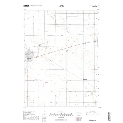
2017 Map of Holdrege East
USGS Topo · Published 2017About this map
Holdrege serves as the primary hub for this portion of Phelps County, showcasing a dense grid of streets and avenues that transition into the sprawling agricultural landscape of south-central Nebraska. The area's dependence on water management is evident through the winding path of the Phelps County Canal and the natural drainage of Sacramento Cr. Small communities like Funk and Sacramento appear as quiet clusters among the section lines, while aviation needs are met at Brewster Field northeast of the main town site. Genealogists and local historians can locate several burial grounds, including Prairie Home Cem, Bethel Cem, and Prairie Cem, which anchor the rural surroundings. The southern portion of the map is defined by natural lowlands such as Richardson Lagoon, illustrating the varied prairie hydrology that exists alongside an extensive network of county roads.
Find a feature on this map
56 named features on this map. Tap any name to fly to it.
Don’t see what you’re looking for? This feature index may not catch every label — zoom into the map to look around manually.
Map Details
Editions of this 2017 Holdrege East Map
This is the sole edition of this map. No revisions or reprints were ever made.
Other maps of this area

1894 · Kearney
USGS Topo · 1:62,500

1896 · Holdrege
USGS Topo · 1:125,000

1896 · Kearney
USGS Topo · 1:125,000

1955 · Grand Island
USGS Topo · 1:250,000

1957 · Grand Island
USGS Topo · 1:250,000

1958 · Grand Island
USGS Topo · 1:250,000

1970 · Holdrege East
USGS Topo · 1:24,000

1970 · Axtell West
USGS Topo · 1:24,000
1970 · Elm Creek SE
USGS Topo · 1:24,000

1970 · Wilcox
USGS Topo · 1:24,000
Featured Places
- Holdrege, NE
- Funk, NE
- Dewaynes Trailer Court, Holdrege
- Sacramento, NE
- Westside Plaza Mobile Home Park, Holdrege