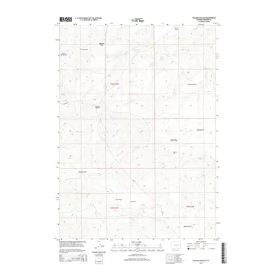
2015 Map of Holdup Hollow
USGS Topo · Published 2015About this map
Birkner Hill and the elevated plateau of Turner Divide dominate this landscape in Converse County, where the high plains are carved by a complex network of ephemeral watercourses. This modern survey illustrates the essential role of water management in an arid environment, centered around Silver Spoon Reservoir and numerous reliable water sources like White Rock Spring and Martin Spring. The geography is defined by broad, flat benches such as Turner Flats and Highland Flats, which stand in contrast to the deep erosional patterns of Hornbeck Draw and Spillman Draw. The small settlement at Blizzard Heights provides a rare human anchor in a region otherwise characterized by vast ranching tracts and township boundaries. Transport is limited to rugged routes like Ross RD and CR 31, which follow the natural contours of the drainages including Willow Cr and its tributaries.
Find a feature on this map
26 named features on this map. Tap any name to fly to it.
Don’t see what you’re looking for? This feature index may not catch every label — zoom into the map to look around manually.
Map Details
Editions of this 2015 Holdup Hollow Map
This is the sole edition of this map. No revisions or reprints were ever made.
Other maps of this area

1949 · Gilbert Lake
USGS Topo · 1:24,000

1949 · Leuenberger Ranch
USGS Topo · 1:24,000

1949 · Hylton Ranch
USGS Topo · 1:24,000

1950 · Gilbert Lake
USGS Topo · 1:24,000

1950 · Leuenberger Ranch
USGS Topo · 1:24,000
1950 · Hylton Ranch
USGS Topo · 1:24,000

1954 · Torrington
USGS Topo · 1:250,000

1955 · Newcastle
USGS Topo · 1:250,000

1958 · Torrington
USGS Topo · 1:250,000

1958 · Newcastle
USGS Topo · 1:250,000