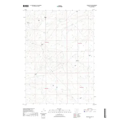
2017 Map of Holdup Hollow
USGS Topo · Published 2017About this map
Birkner Hill and the Turner Divide dominate this high-plains landscape in Converse County, where the topography is defined by a network of seasonal draws and creeks. This 2017 survey shows a region largely characterized by ranching and resource management, with small settlements like Blizzard Heights and Highland Flats positioned near critical water sources. The importance of water in this semi-arid environment is evidenced by the numerous named springs and reservoirs, such as White Rock Spring and the Silver Spoon Reservoir. A series of deep drainages, including Martin Spring Draw and Hornbeck Draw, carve through the terrain, illustrating the natural erosion patterns that have shaped the local geography. The presence of Co RD 31 provides the primary transit artery through these ranch lands, connecting the isolated high points like Morris Hill with the surrounding valleys.
Find a feature on this map
26 named features on this map. Tap any name to fly to it.
Don’t see what you’re looking for? This feature index may not catch every label — zoom into the map to look around manually.
Map Details
Editions of this 2017 Holdup Hollow Map
This is the sole edition of this map. No revisions or reprints were ever made.
Other maps of this area

1949 · Gilbert Lake
USGS Topo · 1:24,000

1949 · Leuenberger Ranch
USGS Topo · 1:24,000

1949 · Hylton Ranch
USGS Topo · 1:24,000

1950 · Gilbert Lake
USGS Topo · 1:24,000

1950 · Leuenberger Ranch
USGS Topo · 1:24,000
1950 · Hylton Ranch
USGS Topo · 1:24,000

1954 · Torrington
USGS Topo · 1:250,000

1955 · Newcastle
USGS Topo · 1:250,000

1958 · Torrington
USGS Topo · 1:250,000

1958 · Newcastle
USGS Topo · 1:250,000