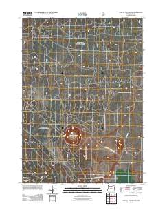
2011 Map of Hole In The Ground
USGS Topo · Published 2011About this map
Hole in the Ground, a large maun-type volcanic explosion crater, dominates this landscape in northern Lake County. The map provides a detailed view of the remote high desert terrain within the Cabin Lake Ft Rock Wildl Area, characterized by a sparse network of service and access roads. The infrastructure here is primarily managed for land and wildlife conservation, evidenced by the presence of Bureau of Land Mgmt Rd 6149-A 0 and several numbered forest routes such as 200 Rd and 750 Rd. This 2011 survey captures the area as a dedicated wildlife management zone, where the natural geology of the Hole in the Ground crater remains the central geographical landmark, surrounded by the open spaces of the Oregon outback.
Find a feature on this map
8 named features on this map. Tap any name to fly to it.
Don’t see what you’re looking for? This feature index may not catch every label — zoom into the map to look around manually.
Map Details
Editions of this 2011 Hole In The Ground Map
This is the sole edition of this map. No revisions or reprints were ever made.
Other maps of this area

1931 · Newberry Crater
USGS Topo · 1:125,000

1935 · Newberry Crater
USGS Topo · 1:125,000

1955 · Crescent
USGS Topo · 1:250,000

1957 · Crescent
USGS Topo · 1:250,000

1958 · Crescent
USGS Topo · 1:250,000
1963 · Spring Butte
USGS Topo · 1:24,000

1970 · Crescent
USGS Topo · 1:250,000

1979 · Crescent
USGS Topo · 1:100,000
1981 · Wickiup Spring
USGS Topo · 1:24,000
1981 · Fort Rock
USGS Topo · 1:24,000