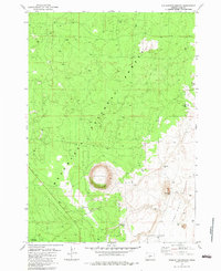
1982 Map of Hole-In-The-Ground
USGS Topo · Published 1983About this map
Hole in the Ground, a massive volcanic maar, dominates the high desert landscape of Lake County within this 1982 survey. The map details a transition from the wooded slopes of the Deschutes National Forest and Fremont National Forest to the arid expanse of the Fort Rock Valley. Evidence of early settlement and pastoral life is scattered throughout the region, marked by sites such as Ryan Cabin and the former location of Fremont.
Find a feature on this map
17 named features on this map. Tap any name to fly to it.
Don’t see what you’re looking for? This feature index may not catch every label — zoom into the map to look around manually.
Map Details
Editions of this 1982 Hole-In-The-Ground Map
This is the sole edition of this map. No revisions or reprints were ever made.
Other maps of this area

1931 · Newberry Crater
USGS Topo · 1:125,000

1935 · Newberry Crater
USGS Topo · 1:125,000

1955 · Crescent
USGS Topo · 1:250,000

1957 · Crescent
USGS Topo · 1:250,000

1958 · Crescent
USGS Topo · 1:250,000
1963 · Spring Butte
USGS Topo · 1:24,000

1970 · Crescent
USGS Topo · 1:250,000

1979 · Crescent
USGS Topo · 1:100,000
1981 · Wickiup Spring
USGS Topo · 1:24,000
1981 · Fort Rock
USGS Topo · 1:24,000