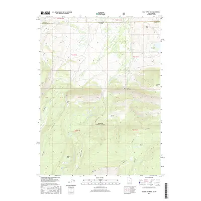
2017 Map of Hole In The Rock
USGS Topo · Published 2017About this map
Wasatch National Forest dominates this high-altitude landscape along the border of Utah and Wyoming, where the drainage of the Beaver Creek forks carves through the northern Uinta Mountains. The small settlement of Hole in the Rock is centered near Hole in the Rock Spring, serving as a focal point for this wilderness area. The map illustrates a complex network of hydrological features, including the W Fork Beaver Cr, Middle Fork Beaver Cr, and E Fork Beaver Cr, which flow north toward the state line. Elevated landmarks like Thompson Peak, Burnt Ridge, and Poison Mtn define the topography, while distinct open areas such as Willow Park, Georges Park, and Beaver Parks indicate the intermittent meadows found within the timber. This survey details the remote backcountry infrastructure of the region, including the access provided by Willow Park Way.
Find a feature on this map
37 named features on this map. Tap any name to fly to it.
Don’t see what you’re looking for? This feature index may not catch every label — zoom into the map to look around manually.
Map Details
Editions of this 2017 Hole In The Rock Map
This is the sole edition of this map. No revisions or reprints were ever made.
Other maps of this area

1885 · Uinta
USGS Topo · 1:250,000

1905 · Gilbert Peak
USGS Topo · 1:125,000

1906 · Gilbert Peak
USGS Topo · 1:125,000

1954 · Salt Lake City
USGS Topo · 1:250,000

1954 · Ogden
USGS Topo · 1:250,000

1958 · Ogden
USGS Topo · 1:250,000

1958 · Salt Lake City
USGS Topo · 1:250,000

1960 · Ogden
USGS Topo · 1:250,000

1960 · Salt Lake City
USGS Topo · 1:250,000
1964 · Lonetree
USGS Topo · 1:24,000