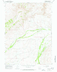
1964 Map of Lonetree
USGS Topo · Published 1968About this map
Henrys Fork defines the agricultural heart of this high-altitude basin in southwestern Wyoming, where a complex network of irrigation channels supports ranching operations. The tiny settlement of Lonetree serves as the focal point for the region, anchored by the Lonetree Cem and nearby Smith Ranch. The landscape is a study in water management, featuring named diversions such as Luckey Ditch, Grimsley Ditch, and the Cedar Basin Ditch that draw from Beaver Creek and other local streams. These man-made features contrast with the prominent natural elevations of Hickey Mountain and the Bald Range. A solitary Radio Tower stands on the heights near Hickey Mountain Reservoir, illustrating the mid-century intersection of traditional mountain ranching and modern telecommunications infrastructure.
Find a feature on this map
25 named features on this map. Tap any name to fly to it.
Don’t see what you’re looking for? This feature index may not catch every label — zoom into the map to look around manually.
Map Details
Editions of this 1964 Lonetree Map
2 editions found
Other maps of this area

1885 · Uinta
USGS Topo · 1:250,000

1905 · Gilbert Peak
USGS Topo · 1:125,000

1906 · Gilbert Peak
USGS Topo · 1:125,000

1954 · Salt Lake City
USGS Topo · 1:250,000

1954 · Ogden
USGS Topo · 1:250,000

1958 · Ogden
USGS Topo · 1:250,000

1958 · Salt Lake City
USGS Topo · 1:250,000

1960 · Ogden
USGS Topo · 1:250,000

1960 · Salt Lake City
USGS Topo · 1:250,000

1964 · Soap Holes Reservoir
USGS Topo · 1:24,000