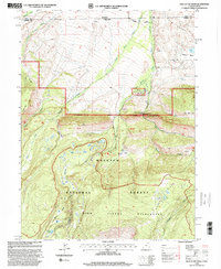
1998 Map of Hole In The Rock
USGS Topo · Published 2001About this map
The Wasatch National Forest straddles the high-altitude boundary between Utah and Wyoming, defined by the prominent peaks of Poison Mtn and the Bald Range. This landscape is fundamentally shaped by the drainage of the Beaver Creek system, including the West Fork, Middle Fork, and East Fork. Historically, the area represents a managed wilderness and resource zone, featuring the Hole in the Rock Guard Station and remnants of extractive efforts like Coal Mine Hill and scattered gravel pits. The mapping reveals a transition from the structured Mountain View Ranger District into the protected High Uintas Wilderness, where the terrain rises toward Burn Ridge. Genealogists and local historians can trace the early infrastructure of the forest service and the primitive road networks like the Lane that provided access to remote grazing corrals and high-country landmarks like Hole in the Rock.
Find a feature on this map
34 named features on this map. Tap any name to fly to it.
Don’t see what you’re looking for? This feature index may not catch every label — zoom into the map to look around manually.
Map Details
Editions of this 1998 Hole In The Rock Map
This is the sole edition of this map. No revisions or reprints were ever made.
Other maps of this area

1885 · Uinta
USGS Topo · 1:250,000

1905 · Gilbert Peak
USGS Topo · 1:125,000

1906 · Gilbert Peak
USGS Topo · 1:125,000

1954 · Salt Lake City
USGS Topo · 1:250,000

1954 · Ogden
USGS Topo · 1:250,000

1958 · Ogden
USGS Topo · 1:250,000

1958 · Salt Lake City
USGS Topo · 1:250,000

1960 · Ogden
USGS Topo · 1:250,000

1960 · Salt Lake City
USGS Topo · 1:250,000
1964 · Lonetree
USGS Topo · 1:24,000