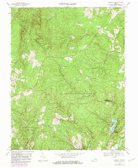
1968 Map of Holiday Lake
USGS Topo · Published 1982About this map
Appomattox-Buckingham State Forest dominates this Central Virginia landscape, illustrating a heavily wooded region defined by its conservation history and timber management. The map details the transition between Buckingham and Appomattox Counties, centered on the recreational and environmental hub of Holiday Lake State Park. Along the Slate River and the upper reaches of the Appomattox River, the terrain rises toward local landmarks like Kyles Mtn and Gunner Mtn.
Find a feature on this map
41 named features on this map. Tap any name to fly to it.
Don’t see what you’re looking for? This feature index may not catch every label — zoom into the map to look around manually.
Map Details
Editions of this 1968 Holiday Lake Map
3 editions found
Other maps of this area

1892 · Buckingham
USGS Topo · 1:125,000

1892 · Appomattox
USGS Topo · 1:125,000

1947 · Roanoke
USGS Topo · 1:250,000

1958 · Appomattox
USGS Topo · 1:62,500

1958 · Pamplin City
USGS Topo · 1:62,500

1959 · Roanoke
USGS Topo · 1:250,000

1961 · Shipman
USGS Topo · 1:62,500

1961 · Buckingham
USGS Topo · 1:62,500

1963 · Roanoke
USGS Topo · 1:250,000

1967 · Andersonville
USGS Topo · 1:24,000