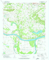
1972 Map of Holla Bend
USGS Topo · Published 1974About this map
Holla Bend National Wildlife Refuge dominates the landscape south of the Arkansas River, occupying a large loop formed by the river's shifting course and the Holla Bend Cutoff. This early 1970s survey captures a transition between the wild river bottoms and the established agricultural and rail communities of Pope and Yell counties. To the north, the Missouri Pacific railroad serves the settlements of Pottsville and Worthen, while the floodplain to the south is marked by the distinct Carden Bottom. Local genealogy is well-documented through a high density of rural burial sites, including Shinn, Pisgah, and Plott. The area's conservation focus is evident in the inclusion of the Galla Creek State Wildlife Management Area, preserving the marshy terrain around Galla Creek and Flagg Lake.
Find a feature on this map
40 named features on this map. Tap any name to fly to it.
Don’t see what you’re looking for? This feature index may not catch every label — zoom into the map to look around manually.
Map Details
Editions of this 1972 Holla Bend Map
2 editions found

Other maps of this area

1888 · Dardanelle #4
USGS Topo · 1:62,500

1888 · Dardanelle #1
USGS Topo · 1:62,500

1889 · Morrilton No. 3
USGS Topo · 1:62,500

1890 · Dardanelle
USGS Topo · 1:125,000

1892 · Morrillton
USGS Topo · 1:125,000

1894 · Morrillton
USGS Topo · 1:125,000

1956 · Russellville
USGS Topo · 1:250,000
1961 · Adona
USGS Topo · 1:24,000
1961 · Atkins
USGS Topo · 1:24,000
1962 · Moreland
USGS Topo · 1:24,000