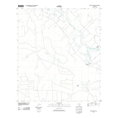
2010 Map of Holland Dam
USGS Topo · Published 2010About this map
The Nueces River winds through this South Texas landscape, serving as the primary hydrological anchor for a series of water management sites in La Salle County. In the early 21st century, this region's infrastructure is defined by its rural road network and specialized reservoirs, including the Allerkamp Reservoir and the Holland Reservoir Site Number 2. The map illustrates a pattern of land use centered on water retention and ranching access, with multiple named structures such as Davis Dam, Holland Dam Site Number 1, and Martin Lake Number 3 Dam regulating the flow of local tributaries. Arid-land drainage is further managed by Arrita Creek and Las Raices Creek, while transit is limited to established ranch routes like Allerkamp Rd and Ranch Rd 624, reflecting the area's sparse, utilitarian settlement character.
Find a feature on this map
14 named features on this map. Tap any name to fly to it.
Don’t see what you’re looking for? This feature index may not catch every label — zoom into the map to look around manually.
Map Details
Editions of this 2010 Holland Dam Map
This is the sole edition of this map. No revisions or reprints were ever made.
Other maps of this area

1927 · Bart
USGS Topo · 1:62,500

1929 · Cotulla
USGS Topo · 1:125,000

1940 · Cotulla
USGS Topo · 1:62,500

1940 · Artesia Wells
USGS Topo · 1:62,500

1953 · Crystal City
USGS Topo · 1:250,000

1955 · Crystal City
USGS Topo · 1:250,000

1957 · Encinal
USGS Topo · 1:62,500

1957 · Caiman Creek
USGS Topo · 1:62,500

1961 · Crystal City
USGS Topo · 1:250,000

1968 · Crystal City
USGS Topo · 1:250,000