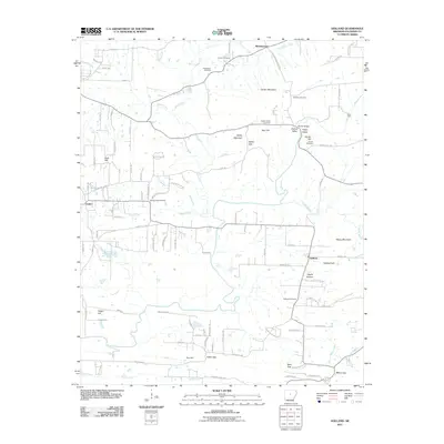
2011 Map of Holland
USGS Topo · Published 2011About this map
Holland and the surrounding Faulkner County countryside are characterized by a network of family-named gaps and hills, where agricultural life persists alongside suburban expansion. The northern portion of the map is defined by the winding course of Tarkington Creek and Prairie Creek, punctuated by small settlements like McGintytown. A high density of family burial grounds, including the Henderson Cemetery and McGinty Cemetery, suggests deep roots in the local community. The landscape is a series of low peaks and passages such as Bailey Mountain, Acklin Gap, and Bass Gap, which historically dictated the flow of travel through this part of the Arkansas foothills. To the east, the terrain rises toward Bayou Mountain and Holland Hill, overlooking the lowlands of Muddy Bayou. The presence of landmarks like Hardin Bridge and the Cow Ford reflects the importance of water crossings in the development of the rural road network connecting these historic communities.
Find a feature on this map
106 named features on this map. Tap any name to fly to it.
Don’t see what you’re looking for? This feature index may not catch every label — zoom into the map to look around manually.
Map Details
Editions of this 2011 Holland Map
This is the sole edition of this map. No revisions or reprints were ever made.
Other maps of this area

1956 · Russellville
USGS Topo · 1:250,000

1961 · Conway
USGS Topo · 1:24,000

1961 · Conway
USGS Topo · 1:62,500

1961 · Bee Branch
USGS Topo · 1:62,500

1961 · Greenbrier
USGS Topo · 1:24,000

1961 · Damascus
USGS Topo · 1:24,000

1961 · Guy
USGS Topo · 1:24,000
1961 · Holland
USGS Topo · 1:24,000
1961 · Hamlet
USGS Topo · 1:24,000

1963 · Enola
USGS Topo · 1:24,000