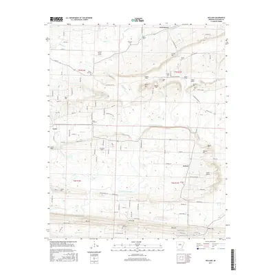
2017 Map of Holland
USGS Topo · Published 2017About this map
Holland and McGintytown anchor this rural Faulkner County landscape, where the meandering course of the East Fork Cadron Creek shapes the local topography. This 2017 survey reveals a complex network of small farm-to-market roads and ridge-top settlements such as Linder, situated near Kaney Ridge. The area is notably dense with family-interest sites, including several small burial grounds like Antioch Cem, Henderson Cem, and the Acklin Graveyard. Significant elevation changes are marked by a series of distinct peaks and gaps, notably Bailey Mtn and Tater Hill, which overlook Cadron Valley. Aviation is represented by local airstrips like Arkavalley Airport and Cantrell Farms Airport, indicating a modern agricultural and recreational economy. Water resources are abundant, ranging from named ponds like Goose Pond to the southern reach of Beaver Fork, providing a detailed look at the watershed before it leaves the quadrangle.
Find a feature on this map
116 named features on this map. Tap any name to fly to it.
Don’t see what you’re looking for? This feature index may not catch every label — zoom into the map to look around manually.
Map Details
Editions of this 2017 Holland Map
This is the sole edition of this map. No revisions or reprints were ever made.
Other maps of this area

1956 · Russellville
USGS Topo · 1:250,000

1961 · Conway
USGS Topo · 1:24,000

1961 · Conway
USGS Topo · 1:62,500

1961 · Bee Branch
USGS Topo · 1:62,500

1961 · Greenbrier
USGS Topo · 1:24,000

1961 · Damascus
USGS Topo · 1:24,000

1961 · Guy
USGS Topo · 1:24,000
1961 · Holland
USGS Topo · 1:24,000
1961 · Hamlet
USGS Topo · 1:24,000

1963 · Enola
USGS Topo · 1:24,000