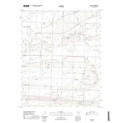
2020 Map of Holland
USGS Topo · Published 2020About this map
Greenbrier and the surrounding rural communities of Faulkner County are defined by a network of small watercourses and family-named landmarks. The landscape is carved by Muddy Bayou, Beaver Fork, and Needs Cr, which drain the area's prominent high points like Clinton Mtn and Hardin Hill. This modern survey details the persistent rural character of the region, where aviation sites like Cantrell Farms Airport and Arkavalley Airport sit alongside historic burial grounds such as Hardin Cem and the Acklin Graveyard. The map captures a moment when traditional settlements like Holland and McGintytown maintain their distinct identities even as modern roads like Arkavalley Rd and Holland Hills Loop weave through the hills. For local historians, the specific naming of small gaps such as Bailey Gap and Bass Gap provides precise geographic context for family land holdings and historical travel routes.
Find a feature on this map
84 named features on this map. Tap any name to fly to it.
Don’t see what you’re looking for? This feature index may not catch every label — zoom into the map to look around manually.
Map Details
Editions of this 2020 Holland Map
This is the sole edition of this map. No revisions or reprints were ever made.
Other maps of this area

1956 · Russellville
USGS Topo · 1:250,000

1961 · Conway
USGS Topo · 1:24,000

1961 · Conway
USGS Topo · 1:62,500

1961 · Bee Branch
USGS Topo · 1:62,500

1961 · Greenbrier
USGS Topo · 1:24,000

1961 · Damascus
USGS Topo · 1:24,000

1961 · Guy
USGS Topo · 1:24,000
1961 · Holland
USGS Topo · 1:24,000
1961 · Hamlet
USGS Topo · 1:24,000

1963 · Enola
USGS Topo · 1:24,000