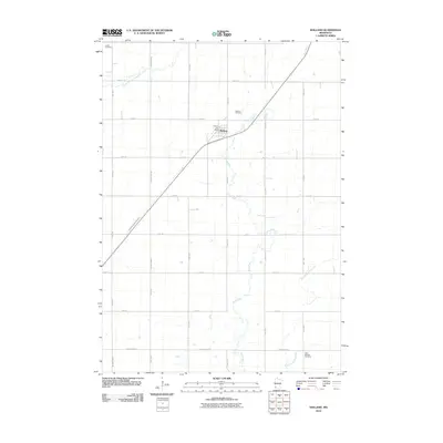
2010 Map of Holland
USGS Topo · Published 2010About this map
Holland serves as the central hub for this corner of Pipestone County, established at the intersection of a sprawling rural road network and the local rail line. The landscape is defined by the meandering courses of the Rock River and its tributaries, including the North Branch Pipestone Creek and the East Branch Rock River, which drain the agricultural plains. A high concentration of burial sites, such as Holland Cemetery, Luctor Cemetery, and Saint Martins Cemetery, provides significant genealogical interest for those tracing family ties in the region. The area's agricultural infrastructure is further detailed by drainage features like County Ditch Number One, illustrating the extensive land management required for prairie farming. The presence of the Holland Post Office marks the community's enduring role as a local service center amidst the grid-patterned township roads of 110th Ave and County Hwy-67.
Find a feature on this map
25 named features on this map. Tap any name to fly to it.
Don’t see what you’re looking for? This feature index may not catch every label — zoom into the map to look around manually.
Map Details
Editions of this 2010 Holland Map
This is the sole edition of this map. No revisions or reprints were ever made.
Other maps of this area

1953 · Watertown
USGS Topo · 1:250,000

1955 · Sioux Falls
USGS Topo · 1:250,000

1958 · Sioux Falls
USGS Topo · 1:250,000

1958 · Watertown
USGS Topo · 1:250,000

1967 · Pipestone North
USGS Topo · 1:24,000

1967 · Edgerton North
USGS Topo · 1:24,000

1967 · Edgerton NE
USGS Topo · 1:24,000
1967 · Ruthton
USGS Topo · 1:24,000

1967 · Ruthton NW
USGS Topo · 1:24,000
1967 · Woodstock
USGS Topo · 1:24,000